Summary
Soil sampling helps producers develop management zones and prescription maps in precision agriculture, increasing the accuracy of rate and placement of necessary inputs (primarily fertilizers and lime to adjust pH). Producers and managers commonly use Grid or Zone Sampling strategies when collecting soil samples. This article helps row crop, specialty crop, and vegetable producers; turfgrass managers; and foresters to identify how and where to collect soil samples.
Introduction
Soil sampling helps to evaluate the pH and nutrient status of a field to base lime and fertilizer management decisions for optimal crop production. Applying lime and fertilizer without checking nutrient status can result in over and under application of chemicals. The number of soil samples to be collected from a field can depend upon the variability of the field’s soil. For example, intensive soil sampling can yield more farm profits if within-field variations in soil texture, cropping history, slope, and nutrient availability are high. Information on these factors can help to determine the number of samples and soil sampling strategy to be used. Recent advances in affordable precision agriculture technologies and tools like global positioning system (GPS), geostatistical tools, and the use of crop sensors to detect plant status and canopy color has led to new precision soil sampling techniques.
The primary goal of using precision soil sampling is to enable variable fertilizer application rates based on need in each zone within a field. In other words, fertilizer application rates are tailored to what is needed in different parts of the field. Precision soil sampling results in higher fertilizer use efficiency, reduced nutrient loss,1 and protection of the surrounding natural resources.2 Precision soil sampling techniques use data from various sources3 including but not limited to
- Yield monitors
- Topographical maps
- Electrical conductivity (EC)
- Spectral reflectance
- Soil color
- Soil nutrient status based on intensive sampling
Precision sampling techniques allow the field to be divided into multiple homogenous management zones and apply nutrients based on the likelihood of the crop to respond to amendments in those zones. For example, soil EC can be measured and mapped using a Veris machine and GPS receiver (figure 1a). Soil EC varies with soil texture,4 which is the amount of sand (largest particle size), silt, and clay (smallest particle size) present. Subsequently, soil texture influences water content and movement, and thus the movement of nutrient elements.5 Therefore, mapping soil EC of a field can help in understanding in-field soil nutrient variations and relate it to yield maps of that field (figure 1b and 1c).
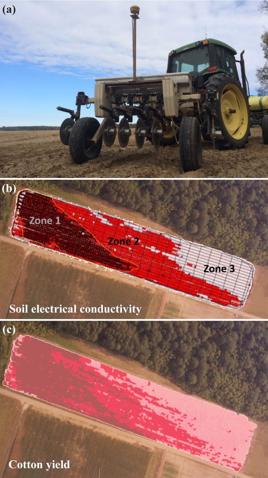
Figure 1. (a) A Veris soil electrical conductivity (EC) machine (Veris Technologies, Salina KS) along with GPS receiver, (b) the resulting map delineating three EC zones (zone 1, zone 2, and zone 3), and (c) cotton yield map. Image credit: Bhupinder S. Farmaha, Clemson University, and Ahmad Khalilian, Clemson University.
Guidelines for Physically Collecting Representative Soil Samples
The collection of representative soil samples from the field is important to provide improved fertilizer and liming recommendations. Soils with different chemical and physical characteristics respond differently when fertilizer and pH adjusting products are applied. Other considerations include previous management of the field (or different sections of the field), size of the field, and crop to be grown. Collect eight to ten individual soil cores per grid sample, ten to fifteen soil cores per management zone, and fifteen to twenty soil cores for a traditional composite sample.6 General guidelines on how to collect soil and prepare a soil sample for analysis can be found on The Clemson University Agricultural Service Laboratory website.
Sampling Equipment
Select the proper tools to collect the sample (figure 2). Intensive soil sampling is the process of collecting many composite soil samples from various locations throughout a field. The collected soil samples are sent to a soil testing lab to measure various soil properties. Soil properties evaluated include pH and buffer pH, extractable phosphorus, potassium, calcium, magnesium, zinc, manganese, copper, boron, and sodium, lime requirements and recommendations, organic matter, cation exchange capacity (CEC), acidity, and percent base saturation (figure 3). This data by itself is not very useful. The farmer must be able to identify where in the field the samples were collected, to know where to apply soil amendments or otherwise modify field operations.
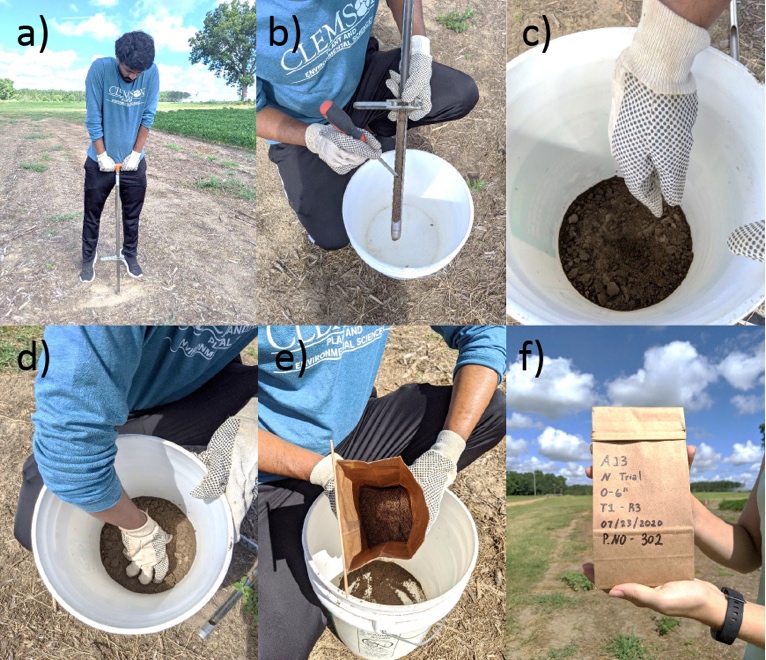
Figure 2. Step-wise process of collecting soil samples (a) soil sample collection using a hand-held push probe, (b) divide each core sample into desired depths, (c) make a composite of samples for each depth in a clean bucket, (d) mix the soil samples, (e) transfer required amount of soil samples in a clean soil sample bag, and (f) label the bag. Image credit: Udayakumar Sekaran, Clemson University.
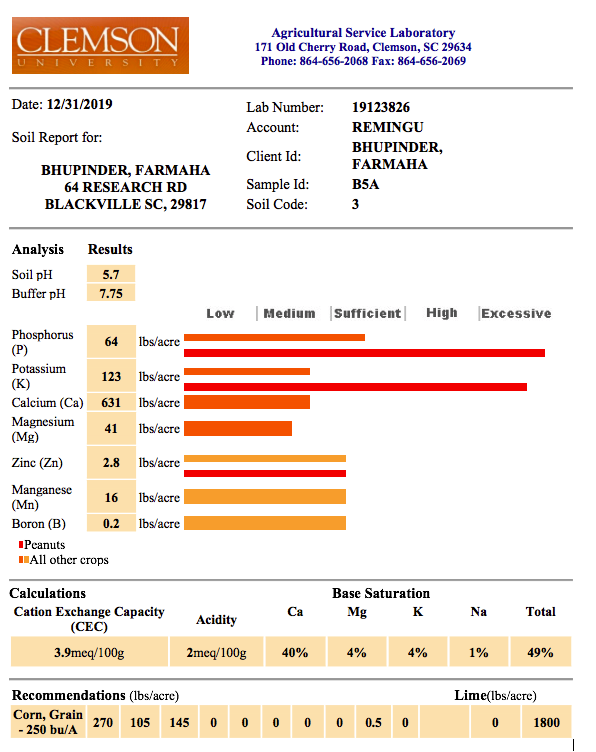
Figure 3. Soil sample tests result from a soil sample sent to the Clemson University’s Agricultural Service Laboratory for analysis of various chemical properties and fertility and pH adjustment recommendations. Image credit: Bhupinder S. Farmaha, Clemson University.
Precision soil sampling involves giving each sample an identification number with geo-reference data from a GPS unit as it is collected. Numbering and geo-referencing each sample allows the farmer to (a) precisely identify where each sample came from and where the information should be used and (b) measure changes in nutrient status over time to allow for variable rate prescriptions to be developed and implemented in the future. Soil sampling is generally done with vehicle-mounted equipment, which simply drills the sample and leaves the operator to package and label it. A multitude of different systems of varying complexity and cost are available for collecting soil samples. Perhaps more important than how samples are collected is understanding how to select a sampling site and when you should collect the soil samples.
How to Select Sampling Sites
One of the most critical steps in the sampling process is the selection of sampling sites. Three main techniques are used to select the sites for soil sampling, and these include Cell Sampling, Point Sampling, and Directed Sampling. All three methods divide the field into multiple zones, but they differ in how these zones are created and where within the zones the samples need to be collected. Cell Sampling and Point Sampling are closely related and fall under the collective title of Grid Sampling. The third method, called Directed Sampling (also known as zone sampling), uses a different zone setup from the other two.
The sampling method chosen depends on a few factors. Primarily, how much historical data is available for the field. Historical data includes management practices (e.g., tillage methods, chemicals applied, and cropping history) and yields. The cost and desired level of detail will also influence which method is selected. If historical information is available, then directed sampling should be used to reduce the overall cost. If records were not kept or the field has not been cultivated before, one of the two grid sampling methods should be used to ensure maximum accuracy, as this will help the grower to apply nutrients with precision equipment.
Grid Sampling (Point and Cell)
In Grid Sampling, the entire field is divided into equal squares. Once samples and results are obtained, a soil map can be created and utilized to delineate zones of cells with similar characteristics within the field.
There are several different methods for selecting the exact location of the samples to be taken within a cell. In Point Sampling, core samples from the center of each grid square are collected, mixed in a 5-gallon bucket, and a subsample used for analysis. Another type of Point Sampling is to do the same process for each intersection of the grid lines (figure 4). For this method to work, samples should be collected between 100 ft (four samples per acre) to 200 ft (one sample per acre) apart. The second commonly used grid sampling method is Cell Sampling. Cell Sampling involves collecting core samples from various locations within each cell. Most often, a zigzag pattern is used to effectively cover the entire cell (figure 4). Once collected, mix samples in a small bucket and take a representative subsample for analysis. Cell Sampling is a less intensive sampling method than Point Sampling. Other methods may call for sampling the predominant soil type in each grid, or the predominant geographic feature (e.g., for a zone largely made up of a slope, sample the summit and side slope but not the shoulder or toe slope).
These sampling methods intend to create a representation of the “average soil” of each grid cell. Of the methods, Point Sampling gives a better characterization of field variability but requires the collection of more samples. In comparison, Cell Sampling requires fewer samples, and cells can be of any size, but less field variability is captured.6 For fields that have been under cultivation for many years, particularly those which have been conventionally tilled and treated with blanket applications of chemicals, costs may be reduced by expanding the grid squares. While not ideal, this will still provide a reasonable estimation of field characteristics due to the relative uniformity of field management. Regardless, both methods are useful when there is little prior knowledge of the field.
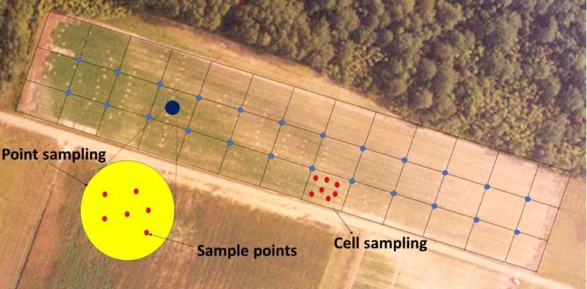
Figure 4. Point Sampling is when cores are collected in the very middle of a cell, or at corners of each cell. Cell Sampling includes collecting cores throughout the entire cell. Image credit: Udayakumar Sekaran, Clemson University.
Direct (Zone) Sampling
Direct Sampling eliminates the need for a grid system. Zones will be created based on historical data such as yield maps, EC maps, topography, and management practices. Adjacent areas with similar characteristics are lumped together, while disparities will create zone boundaries. This process tends to result in larger zones than those created using Grid Sampling. A zone map based on Natural Resources Conservation Service (NRCS) Web Soil Survey, websoilsurvey.sc.egov.usda.gov, is a good starting point; however, zone maps lack detailed information about specific soil properties because of the scale at which sampling occurred. For example, in figure 5, the zones based on map units do not account for the visibly apparent differences in soil organic matter and other soil properties.
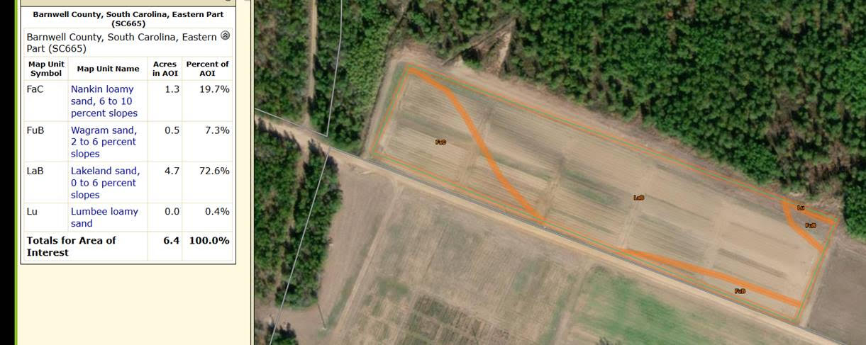
Figure 5. Rough delineations of management zones can be determined by map units identified by the Natural Resources Conservation Service (NRCS) Web Soil Survey, websoilsurvey.sc.egov.usda.gov. The orange lines delineate the different map units and zones. However, these delineations should be ground-truthed as they do not account for all soil differences. Image credit: Udayakumar Sekaran, Clemson University.
Zone Sampling is commonly used because it often results in fewer, larger zones and thus is subsequently less costly and time-consuming (figure 1b). The soil map is not as accurate as one based on Grid Sampling because fewer soil cores are taken. However, it still provides a good representation of the soil characteristics, especially when considered in conjunction with the data used to differentiate the zones.
When creating zones based on historical information, incorporate data from multiple years. Integrating data from multiple years will minimize the risk of making decisions based on anomalies or atypical events. If there is not enough historical data available, geographic or topographic map units, substantial slope variation, or even soil color and general texture can help delineate zones (figure 5). If the field is terraced or if strip cropping is planned, each crop zone should be sampled separately, even if historical information is similar, to help establish a baseline for future data analysis and decision making. Features such as old fence lines or hedgerows, drainage ditches, irrigation zones, and turn rows should also be considered as zone defining, as they may cause or have caused differences in soil structure, nutrient availability or leaching, and compaction.
When to Sample
Collect samples after harvest and as close to the next planting as possible.7 Pre-planting activities (e.g., liquid chemical application, pre-irrigation, and litter/manure spreading) modify soil conditions and should be considered when deciding when to sample. To incorporate multi-year data, conduct sampling at the same time every year to eliminate seasonal variability. Arguments can be made for various schedules, but consistency in the timing of sample collection is the key.
Contact your local Extension Agent for more information and assistance on soil sampling and precision agriculture.
Acknowledgments
The authors would like to thank Dr. Udayakumar Sekaran for his careful review of this paper.
References Cited
- Khosla R, Fleming K, Delgado JA, Shaver TM, Westfall DG. Use of site-specific management zones to improve nitrogen management for precision agriculture. Journal of Soil and Water Conservation. 2002 Nov [accessed 2020 June 8];57(6):513–518.
- Hedley C. The role of precision agriculture for improved nutrient management on farms. Journal of the Science of Food and Agriculture. 2015 [accessed 2020 June 8];95:12–19.
- Hornung A, Khosla R, Reich R, Inman D, Westfall DG. Comparison of site-specific management zones: soil-color-based and yield-based. Agronomy Journal 2006 [accessed 2020 June 8];98:407–415.
- Hedley CB, Yule IJ, Eastwood CR, Shepherd TG, Arnold G. Rapid identification of soil textural and management zones using electromagnetic induction sensing of soils. Soil Research. 2004 [accessed 2020 June 8];42(4):389-400.
- Abd-Elmabod SK, Jordán A, Fleskens L, Phillips JD, Muñoz-Rojas M, van der Ploeg M et al. Modeling agricultural suitability along soil transects under current conditions and improved scenario of soil factors. In Pereira P, Brevik E, Muñoz-Rojas M, Miller B, editors. Soil mapping and process modeling for sustainable land use management. Netherlands: Academic Press. 2017. p. 193–219. doi:10.1016/B978-0-12-805200-6.00007-4.
- Thompson AN, Shaw JN, Mask PL, Touchton JT, Rickman D. Soil sampling techniques for Alabama, USA grain fields. Precision Agriculture. 2004 [accessed 2020 June 8];5:345–358.
- Lory J, Cromley S. Soil sampling hayfields and row crops. 2006. Nutrient Management. MU Extension, University of Missouri-Columbia. 2006 [accessed 2020 August 6]. G9217.