Background
South Carolina has about 4.5 million acres of wetlands, comprising about 23% of the state’s land area, but 90% of wetlands are freshwater and 10% are coastal.1 South Carolina’s coastal wetlands are incredibly diverse ecosystems comprised of numerous habitat types that are ecologically, economically, and culturally important to the inhabitants in and around them. These coastal wetland ecosystems are well-known assets to the state yet have suffered tremendous loss in size from historic levels, like much of the world’s wetlands have. South Carolina has lost about 27% of its wetlands (1,755,000 acres lost), including both freshwater and coastal wetlands, since the mid-1700s.1 Growth and development are largely responsible for this loss, but through the collective efforts of public and private conservationists, an increasing amount of South Carolina’s wetlands are being protected and preserved for future generations.
In order to better understand South Carolina’s coastal wetlands, it is very important to assess their availability and characteristics. In this study, South Carolina’s coastal wetlands are defined as National Wetland Inventory (NWI) wetlands within the South Carolina Department of Health and Environmental Control (SCDHEC) Critical Area. The NWI database is a publicly available resource that provides detailed information on the abundance, characteristics, and distribution of wetlands in the United States.2 The Critical Area is defined as coastal waters, tidelands, beaches, and beach/dune systems.3 Within the defined coastal wetlands, seven habitat types were identified, mapped, and measured in size. With a more in-depth knowledge of the habitats found in South Carolina’s coastal wetlands, coastal wetlands were separated into three regions: the Grand Strand Area, the Greater Charleston Area, and the Greater Hilton Head Area, where more focus could be applied to habitat composition, rates of change, and conservation in the respective regions.
Habitat Analysis and Description
South Carolina’s coastal ecosystem is heavily influenced by its tidal range. The coast’s marshland habitats are intertidal, meaning that the tide ebbs and flows twice a day within these habitats. There are four zones that comprise an intertidal marsh system: (1) the spray zone, which is dampened by ocean spray and is only inundated with water during very high tides and storm surge; (2) the high intertidal zone, which floods during the peak of high tides but remains dry for long periods of time; (3) the middle intertidal zone, which experiences tidal flooding and recession twice daily; and (4) the low intertidal zone, which is almost always underwater with the exception of the lowest of spring tides. Subtidal coastal lands are also an important component of coastal ecosystems. These areas experience normal tidal pulls but remain inundated with water at all times. Amongst these zones, this coastal ecosystem can be broken down into specific habitat types found within the NWI classification system (table 1), consisting of live oyster reefs, washed shell deposit oyster reefs, forested/scrub intertidal, tidal mudflats, beach/sandy shores, marshes, and coastal subtidal coastal lands.
Table 1. Coastal habitat types, area of South Carolina’s coastal habitats, and source of relevant datasets (2019).
| Habitat Type | Habitat Area (Acres) | Dataset Source* |
| Live oyster reefs | 5,016 | SCDNR |
| Oyster reefs – washed shell deposits | 493 | SCDNR |
| Forested/scrub intertidal | 3,894 | U.S. FWS-NWI |
| Tidal mudflats | 20,244 | U.S. FWS-NWI |
| Beach/sandy shores | 6,242 | SCDHEC-OCRM |
| Marshes | 425,928 | U.S. FWS-NWI |
| Coastal subtidal lands | 1,198,214 | U.S. FWS-NWI |
*SCDNR (South Carolina Department of Natural Resources), U.S. FWS-NWI (U.S. Fish and Wildlife Services, National Wetland Inventory), SCDHEC-OCRM (South Carolina Department of Health and Environmental Control, Ocean and Coastal Management).
Live Oyster Reefs
Live oyster reefs are an important component of coastal habitats. Live oyster reefs are commonly found in the middle and low intertidal zones. These habitats serve as a major structural component to shorelines, stabilizing erosion and marsh loss, and are an integral part of South Carolina’s water quality. Live oyster reefs provide nursery and forage habitat to many of South Carolina’s commercially viable marine species including blue crab, stone crab, shrimp, flounder, speckled trout, redfish, and striped bass. Oysters also improve our coastal water quality, sifting algae from the water column, indirectly filtering the water of excess nutrients. In fact, a single oyster can filter roughly fifty gallons of water per day, and with over 5,000 acres of live oyster reefs in South Carolina, much of the acclaim for the state’s water quality can be attributed to these oyster reefs.4 Higher water quality results in cleaner, clearer water that, in turn, promotes the growth of submerged aquatic vegetation, increasing shoreline stabilization and hazard risk reduction. South Carolina’s live oyster reefs are an important asset to the state’s economy and are a staple in the state’s commercial fishing industry and cultural heritage.
Oyster Reefs – Washed Shell Deposits
Washed shell deposit oyster reefs are part of the South Carolina Oyster Recycling and Enhancement (SCORE) program.5 Like live oyster reefs, washed shell deposit areas are found in both the middle intertidal zone and the low intertidal zone. These areas focus on increasing oyster habitat through shell recycling and community-based restoration. These shell deposits serve as solid surfaces for immature oysters (in larvae stage) to “set” or attach to. Oysters are adapted to setting to other oyster shells and, once set, will establish as living oyster reefs that have many ecological and economic benefits to South Carolina. Globally, 85% of oyster reefs have been lost, making oyster reefs the most severely impacted marine habitat on earth.6 Oyster reef restoration projects in South Carolina are an indication of the efforts to restore oysters back to historic levels, promoting better water quality; more habitat for flora and fauna; and a stronger buffer against storms, sea-level rise, and boat wakes.
Forested/Scrub Intertidal
Forested/scrub intertidal is a habitat classification that includes land cover units that fall under the following regime: Estuarine – Intertidal – Scrub/Shrub and Forested. Found within the spray zone and the high intertidal zone, these are low-lying scrub and forested areas that are periodically inundated with tidal waters. The forested/scrub intertidal wetland habitat is a good indicator of the wetland/upland transition zone. These habitats include bottomland forests, hammock islands, and low maritime forests. It is important to note that tidal freshwater forested wetlands have been omitted in this study because their tidal cycle lacks a saltwater component. This omission does not diminish the importance of these habitats on the coastal counties’ landscape and is left out of the scope of conversation because of how coastal wetlands have been defined within the SCDHEC critical area. Forested and scrub wetland habitats aid in oxygen cycling, carbon sequestration, and water filtration. Forested wetlands act as shock absorbers for major storm events and are critical to protecting people and property in the wake of hurricanes.
Tidal Mudflats
Tidal mudflats are coastal wetlands found in intertidal areas where sediments have been deposited by tides or rivers. In South Carolina, these wetlands are commonly found in estuaries and bays. Tidal mudflats are most often found in the middle and low intertidal zones, where the pull of the tide causes the water to recede, exposing bare mud. Part of what makes tidal mudflats such productive components of the ecosystem is that they are found within the intertidal zone, meaning that they are submerged and exposed with the tide twice daily. These areas are highly important to coastal marsh ecology and are a key habitat requirement of migratory shorebirds and numerous other species of crabs, mollusks, and fish.
Beach/Sandy Shores
Beach/sandy shore is a habitat description of South Carolina’s beaches and sandy shores. This habitat component is found in the spray zone and the high intertidal zone. While many of the features of beaches are well known by native South Carolinians and tourists alike, this classification also incorporates sandy habitats that are scattered up and down the South Carolina coast. Many of these beaches and sandy shores are found along the outer edge of South Carolina’s barrier islands where sand is able to move up and down the coast with the currents. These habitats are essential to two at-risk coastal shorebird species that nest in South Carolina: The Wilson’s Plover and the American Oystercatcher. Beaches and sandy shores also serve as nesting grounds for several species of sea turtles that frequent South Carolina’s coastal waters.
Marshes
Marsh is a term used to represent habitats dominated by grasses in both salty and brackish portions of the coastal ecosystem. Marsh systems are complex and can fluctuate in elevation. Marsh can be found in both the high intertidal zone and middle intertidal zone. The dominant plant species found in tidal salt marsh is smooth cordgrass (Spartina alterniflora), but brackish and salt marshes are home to a variety of plant species such as glasswort, salt marsh aster, black needle rush, and sea oxeye.7 These coastal marshes provide critical ecosystem services like shoreline stabilization; wave attenuation; provision of nursery and foraging habitat for commercially and ecologically important species of plants and animals; water quality enhancement; carbon sequestration; and much more.
Coastal Subtidal Lands
Coastal subtidal wetlands are shallow open-water bodies that are influenced by the tides but remain covered with water. South Carolina experiences diurnal tides, two high and two low tides each day. In the Charleston area, the average high tide range is about 5½ feet, whereas during a “King Tide” event, it could reach up to seven feet or higher.8 The regional maps included in this publication also feature subtidal marine and estuarine environments, in addition to the intertidal habitats found in coastal South Carolina.
South Carolina Regional Comparison
Grand Strand Area
The Grand Strand Area extends from upper Horry County near Little River to the southern edge of Georgetown County, terminating at Winyah Bay (figure 1). In this region, beach and sandy shore habitats dominate the coastal landscape through North Myrtle Beach, Myrtle Beach, Surfside Beach, Murrells Inlet, Litchfield Beach, and Pawley’s Island, making up the largest stretch of continuous beach on the East Coast. Sandy shore habitat is interrupted at Winyah Bay, where a more estuarine habitat forms at the confluence of the Waccamaw River, the Pee Dee River, the Black River, and the Sampit River. Winyah Bay and its surrounding marshland is a large and highly diverse estuary comprised of marsh, live oyster reefs, tidal mudflats, beach and sandy shores near the mouth of the bay, subtidal waters, and forested and scrub upland transitional zones.
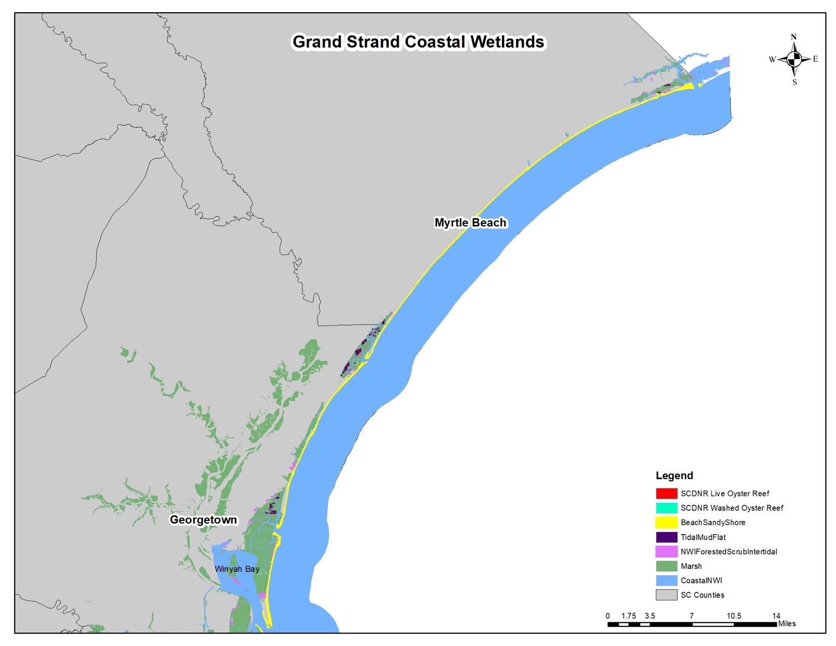
Figure 1. Coastal wetland habitats in South Carolina’s Grand Strand area (2019).
Horry and Georgetown Counties have been subject to growth, as much of the state has, increasing in population by 27.9% and 3.2% since 2010, respectively.9 One area of concern in the region is Waties Island, which is located adjacent to Hog Inlet near Little River. While part of Waties Island, an undeveloped barrier island near the North Carolina border, is protected through Coastal Carolina University, much of the island is privately owned and is subject to possible development. Both Hog Inlet and Murrells Inlet have been troubled with water quality issues in recent years, threatening the local way of life and important shellfish industry. The added pollutants are putting more strain on an already shrinking marsh system in the Grand Strand, giving rise to an increased focus on water quality improvements. Pollutants found in the waters of these areas are being monitored SCDHEC’s Shellfish Sanitation Program. With that said, conservation efforts have had success in parts of the region.
Over 56,000 acres of the Winyah Bay is now protected, and there are thousands of acres under conservation easements on public and private lands, preserving critical habitat and protecting and enhancing biodiversity.10 Public conservation areas include Waccamaw National Wildlife Refuge, Waccamaw River Heritage Preserve, Santee Coastal Wildlife Management Area, Santee-Delta Wildlife Management Area, Samworth Wildlife Management Area, and Lewis Ocean Bay Heritage Preserve. These areas encompass the coastal habitats in the region and serve as excellent public access points to enjoy the beauty and recreational opportunities found in the coastal wetlands of the Grand Strand area.
Greater Charleston Area
The Greater Charleston Area is made up of Charleston County, Berkley County, and Dorchester County (figure 2). Coastal habitats in these counties form at the north end of Bulls Bay above Awendaw and span all the way to Kiawah, Seabrook, and Edisto Islands (although Edisto Island is in Colleton County and is considered part of the Greater Hilton Head area). The upper reaches of Bulls Bay to the north end of the Charleston harbor makes up the longest continuous stretch of marsh in South Carolina, roughly forty miles. This region serves as a highly prolific area for live oyster reefs and tidal mudflats, as well as beaches and sandy shores, including popular tourist destinations such as the Isle of Palms and Sullivan’s Island beaches. Charleston Harbor forms at the mouth of the Ashley, Cooper, and Wando Rivers. These riverine systems are dominated by subtidal and marsh habitats, with some oyster reef, forested/scrub intertidal wetland, and tidal mudflats as well. South of Charleston Harbor, coastal habitat is similar, mainly comprised of marsh, tidal mudflats, and live oyster reefs. Beaches and sandy shores line the coast, and subtidal waters are found in the bays, inlets, rivers, and deepwater creeks.
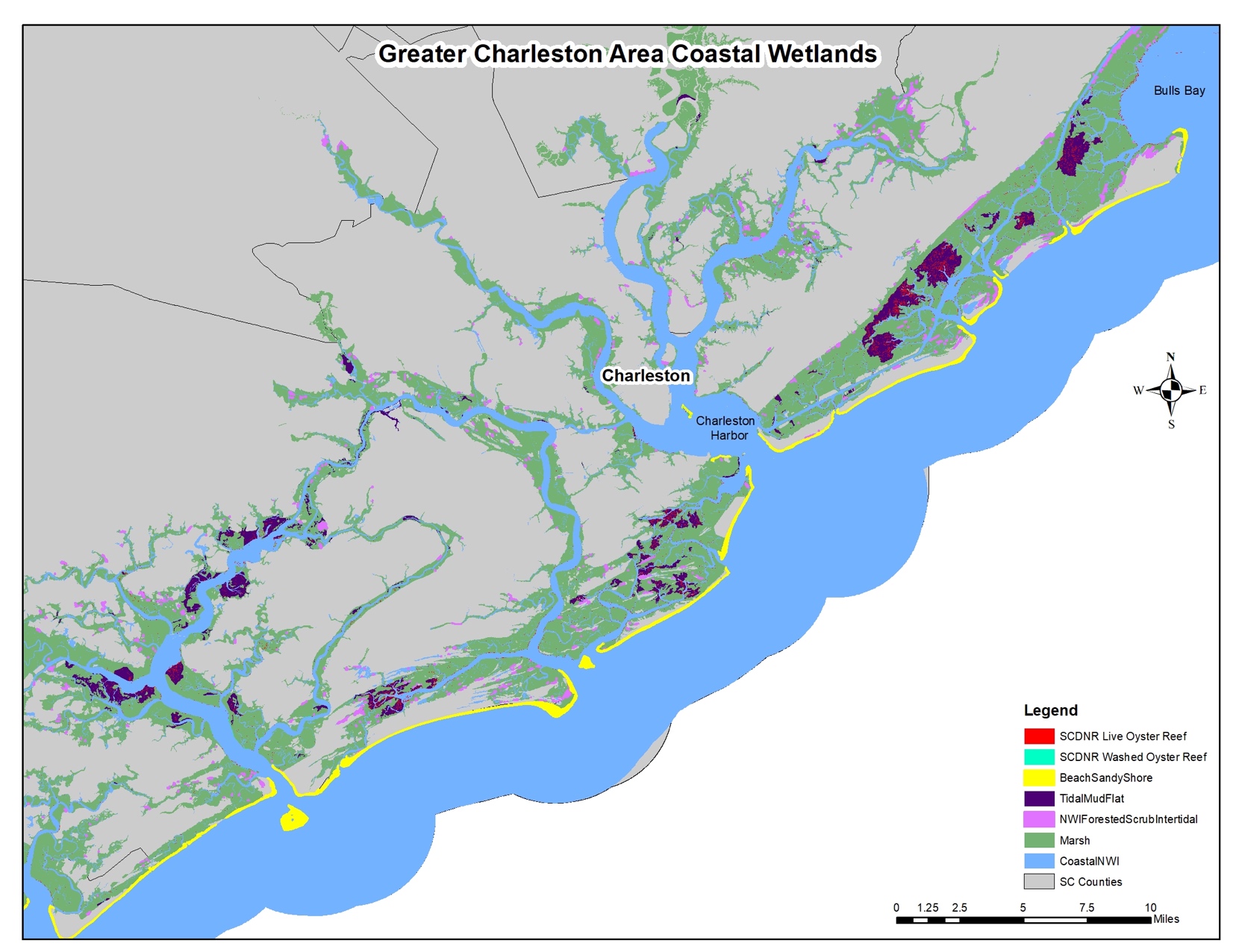
Figure 2. Coastal wetland habitats in South Carolina’s Greater Charleston Area (2019).
Fringing these coastal habitats, the Greater Charleston Area is one of the fastest growing regions in the country. According to the U.S. Census Bureau, since 2010, the Charleston County population has grown by 15.9%, the Dorchester County population has grown by 18%, and the Berkeley County population has grown by 24%.9 As Charleston continues to grow and develop, conservation of these coastal habitats is becoming more critical than ever. Fortunately, places like Cape Romain National Wildlife Refuge, which protects roughly 66,000 acres of coastal habitats around Bulls Bay at the upper reaches of Charleston County, has preserved thousands of acres of critical habitat for native flora and fauna.11 This coastal area is responsible for providing numerous ecosystem services to the Greater Charleston Area and offers excellent recreational opportunities to the general public.
Greater Hilton Head Area
The Greater Hilton Head Area comprises Colleton County, Beaufort County, and Jasper County, and for the purposes of this report, the southern end of Charleston County (figure 3). This coastal region is home to a tremendous estuarine system, starting at St. Helena Sound, extending southward to Port Royal sound, and ending at the Savannah River on the South Carolina-Georgia border. St. Helena Sound forms at the mouth of the Ashepoo, Combahee, and Edisto rivers, also known as the ACE Basin. St. Helena Sound and the three rivers that converge at the sound constitute vast acres of marshland, tidal mudflats, and live oyster reefs, as well as sub-tidal coastal waters found in the sound itself. The coastal marshes and wetlands found in Beaufort county and Jasper county serve as barriers against storm and flood events, help with water quality, and provide outdoor recreational opportunities for a growing population.
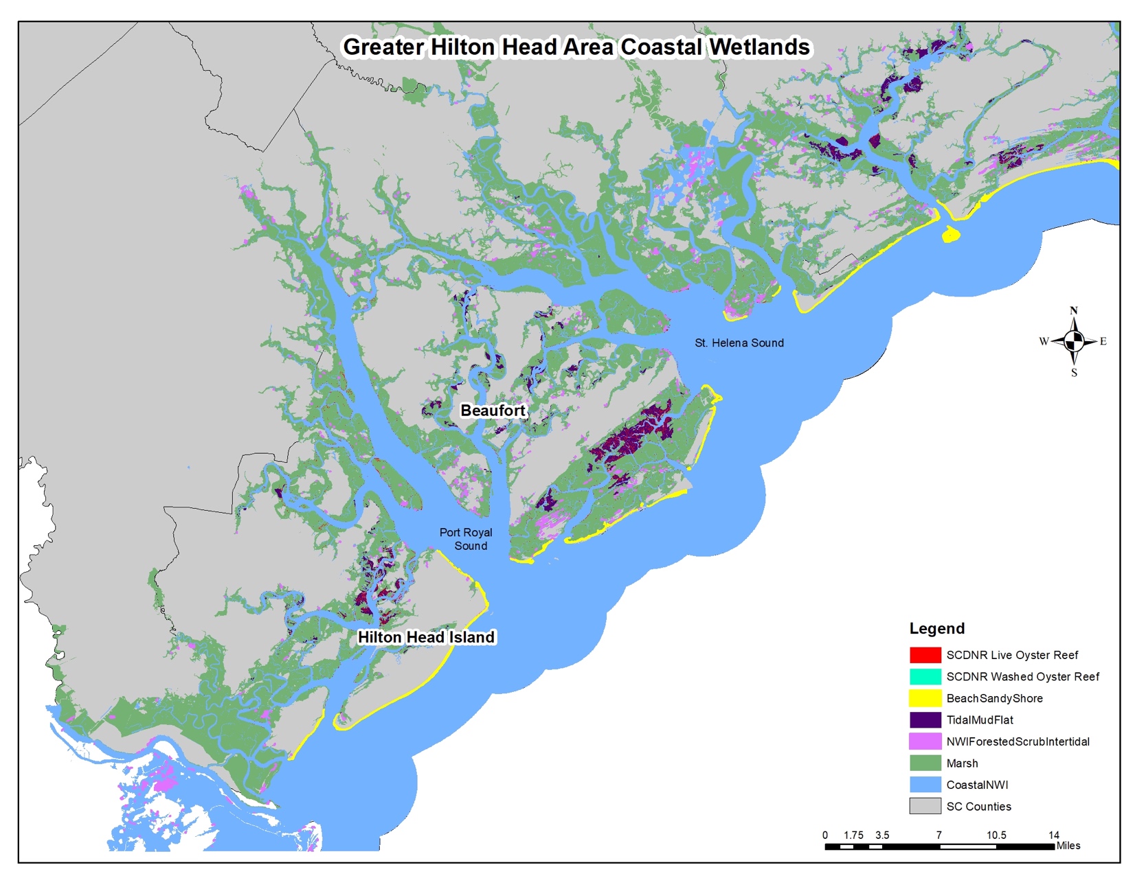
Figure 3. Coastal wetland habitats in South Carolina’s Greater Hilton Head Area (2019).
Progress has been made with conservation efforts, but growth and development are also increasing as more people move to coastal South Carolina. Data from the U.S. Census Bureau suggests that the Greater Hilton Head Area is one of the fastest growing regions in South Carolina. While Colleton County’s population declined 3.2% since 2010, Beaufort County has grown 16.3% and Jasper County has grown 16.9%.9 This explosive growth, in counties that are heavily comprised of coastal wetlands, will put more strain on coastal habitats than ever before.
The ACE Basin is one of the largest undeveloped estuaries in the country and a true conservation success story, with over 250,000 of its 350,000 acres protected over the past thirty years through federal, state, local, and private efforts, under the umbrella of the ACE Basin Task Force.12 Along with numerous privately conserved lands, the ACE Basin is also home to public lands like the ACE Basin National Estuarine Research Reserve, Ernest F. Hollings National Wildlife Refuge, Bear Island Wildlife Management Area, Donnelly Wildlife Management Area, and St. Helena Sound Heritage Preserve. These areas provide the general public with numerous outdoor recreational opportunities that, thanks to conservation efforts, will be available for generations to come. Port Royal Sound shares a similar habitat composition to St. Helena Sound, but also has large tracts of beaches and sandy shores found on Fripp Island, Pritchards Island, St. Phillips Island, and Hilton Head Island. Areas like Pinckney Island National Wildlife Refuge and Savannah National Wildlife Refuge can be found south of Port Royal sound and conserve roughly 35,000 acres of coastal habitat between South Carolina and Georgia.
Summary
South Carolina’s coastal habitats have a profound impact on the people and wildlife that live in and around them. In an ever-changing world, it is important to monitor the dynamics of natural resource systems. By understanding what these habitats are, their relative abundance, and the efforts put in place to protect them, these incredibly valuable coastal wetland systems can be enjoyed for generations to come.
Acknowledgments
A publication sponsored by the South Carolina Sea Grant Consortium and the State of South Carolina pursuant to National Oceanic and Atmospheric Administration Award NA14OAR4170088.
References Cited
- State wetland protection: Status, trends and model approaches. A 50-state study. Washington (DC): Environmental Law Institute; 2008. [accessed 2019 November 21]. https://www.eli.org/sites/default/files/docs/core_states/South_Carolina.pdf.
- National wetlands inventory. Washington (DC): U.S. Fish and Wildlife Service. 2019. [updated 2019 Oct 15]. https://www.fws.gov/wetlands/.
- Kecinski M, Messer K, Peo A. Consumer references for oysters. Newark (DE): Department of Applied Economics and Statistics, University of Delaware; 2015.
- Critical area permitting – overview. Columbia (SC): South Carolina Department of Health and Environmental Control; 2019. https://www.scdhec.gov/environment/your-water-coast/ocean-coastal-management/beach-management/coastal-permits/critical-1.
- South Carolina Oyster Recycling and Enhancement: Background. Columbia (SC): South Carolina Department of Natural Resources; 2019. https://score.dnr.sc.gov/deepc9f3.html.
- Beck M, Brumbaugh RD, Airoldi L, Carranza A, Coen LD, Crawford C, Defeo O, Edgar GJ, Hancock B, Kay MC, Lenihan HS, Luckenbach MW, Toropova CL, Zhang G, Guo X. Oyster reefs at risk and recommendations for conservation, restoration, and management. BioScience. 2011 Feb;61(2):107–116.
doi:10.1525/bio.2011.61.2.5. - Tiner R. An inventory of South Carolina’s coastal marshes. Charleston (SC): U.S. Department of Commerce NOAA; 1974. https://www.govinfo.gov/content/pkg/CZIC-qh541-5-s24-i58-1974/html/CZIC-qh541-5-s24-i58-1974.htm.
- Coastal Zone Management. Columbia (SC): South Carolina Department of Health and Environmental Control; 2019. [accessed 2019 November 21]. https://www.scdhec.gov/environment/your-water-coast/ocean-coastal-management/coastal-zone-management/coastal-hazards/king.
- QuickFacts: South Carolina. Suitland, Suitland-Silver Hill (MD): United States Census Bureau; 2018. [accessed 2019 Nov 21]. https://www.census.gov/quickfacts/SC.
- Cooperative conservation case study: Winyah Bay focus area. Falmouth (ME): Cooperative Conservation America; 2019. http://www.cooperativeconservation.org/viewproject.aspx?id=105.
- Cape Romain: About the refuge. Washington (DC): U.S. Fish and Wildlife Service. 2019. https://www.fws.gov/refuge/Cape_Romain/about.html.
- ACE Basin task force celebrates 25 years of Lowcountry conservation. Memphis (TN): Ducks Unlimited; 2014. https://www.ducks.org/south-carolina/ace-basin-task-force-celebrates-25-years-of-lowcountry-conservation.