Nonpoint source pollution is a major contributor of water pollution in the United States. Because nonpoint source pollution is a diffuse source of pollution, and individual contributing actions are difficult to regulate or enforce, much of the effort aimed at reducing nonpoint source pollution focuses on creating incentives for people to voluntarily change their behavior. This can lead to a piecemeal approach to restoration that fails to consider multiple pollutants and address multiple sources of pollution. In an attempt to create a cohesive approach to restoration, the United States Environmental Protection Agency (EPA) encourages the development of watershed plans to guide efforts to protect and improve surface water quality.1
The Clean Water Act (CWA) regulates surface water quality in the United States. As part of this regulation, the EPA sets national water quality criteria for allowable levels of pollutants.2 Section 303(d) of the CWA, which is administered in South Carolina through the South Carolina Department of Health and Environmental Control (SC DHEC), requires that each state establish water quality standards for their surface waters. Waters of the United States that do not meet the water quality standards for their designated use (e.g. recreation, drinking water supply, agriculture, fishing, etc.) over a period of time may be considered for inclusion on the 303(d) list. Impaired waterbodies that remain on the impaired list for a prolonged period must then have a total maximum daily load (TMDL) established to cap pollutant discharges. A TMDL calculates the maximum amount of a pollutant that can enter a waterbody and the waterbody will still meet water quality standards for that particular pollutant. Watershed-based plans can be an additional tool to protect and restore waterbodies and support a waterbody’s TMDL objective through community education and voluntary best management practice (BMP) implementation.
Watershed plans provide a framework for restoring water quality and preventing future degradation.1 Plan development focuses on assessing all sources of pollution in a watershed, and then identifying BMPs, such as riparian buffers, to reduce pollution from those sources. Watershed plans are typically developed to address existing pollution issues; however, healthy watersheds can also benefit from a plan to protect the water supply and maintain existing water quality. With a final plan in hand, communities have the roadmap they need to guide restoration or protection efforts. SC DHEC approved plans are often necessary to qualify for federal funding opportunities to ultimately implement BMPs in the watershed.
Water Quality in South Carolina
South Carolina has eight major river basins (figure 1), and each is made up of multiple watersheds, which can be broken down further into sub-watersheds. Sub-watersheds are classified as 12-digit Hydrologic Unit Codes (HUCs) by the United States Geological Survey’s watershed classification system.3 There are over 100,000 12-digit HUCs across the United States, and 971 in South Carolina.4 Many of the waterbodies within these sub-watersheds are impaired for one or more pollutants. In fact, 1,041 waterbodies were listed as impaired on the SC DHEC’s 2018 303(d) list, with over 1,200 total impairments (some waterbodies were impaired for more than one pollutant)5 (figure 2). Approximately 35% of these waterbodies are monitored on an ongoing basis.6
Impaired waterbodies can have a variety of negative impacts on overall public health, economic health, and ecosystem health. For example, algal blooms that cause fish kills can also affect water taste and odor and necessitate upgrades to municipal drinking water treatment systems. Other examples include gastrointestinal problems resulting from recreational contact with or consumption of shellfish harvested from impaired waterways, and lost income from a reduction in recreation and/or tourism. Many of these impacts occur downstream from the sources of pollution, so the communities forced to deal with the consequences of impaired waters may not be the cause of the problem.
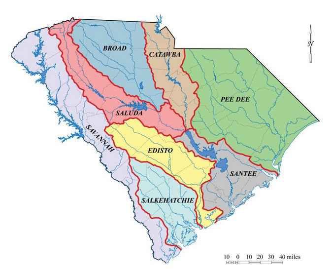
Figure 1: South Carolina’s eight major river basins include the Broad, Catawba, Edisto, Pee Dee, Salkehatchie, Saluda, Santee, and Savannah River Basins. Image credit: SC Water Resources Center, Clemson University.
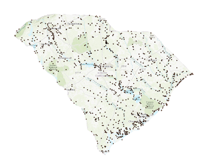
Figure 2: Impaired sites on the SC Department of Health and Environmental Control 303(d) list (2016).7 Image credit: SC Department of Health and Environmental Control.
Fecal bacteria is the most common impairment across South Carolina, followed by nutrients, and nutrient-related impairments (table 1). High levels of bacteria in waterbodies can be from human sources (via poorly functioning septic systems, sanitary sewer overflows or breaks, or discharges from wastewater treatment plants) or animal sources (via wildlife, livestock, or domestic pets). It is difficult to determine the primary source without the use of microbial source tracking, which can be an expensive laboratory analysis. Nutrients often come from land-based applications of fertilizer, but downstream it is challenging to differentiate between agricultural, commercial, or residential sources. The diffuse nature of these pollutants, paired with obstacles in quantifying contributions from each source, adds to the complexity of managing them, particularly for communities lacking analytical expertise or financial resources.
Table 1: SC DHEC’s list of Impairments by Category and Waterbody Type on the 2018 303(d) list.5
| Category | Total Impairments | Lakes | Streams | Estuaries | Shellfish Waters | Beaches |
| Bacteria | 362 | 5 | 167 | 60 | 116 | 14 |
| Nutrients, pH, DO | 197 | 197 | ||||
| Fish Tissue Hg and PCBs | 190 | 190 | ||||
| Macroinvertebrates | 173 | 173 | ||||
| Dissolved Oxygen | 142 | 108 | 34 | |||
| Turbidity | 92 | 13 | 16 | 63 | ||
| Metals | 36 | 4 | 23 | 9 | ||
| pH | 45 | 40 | 5 | |||
| Ammonia Toxicity | 5 | 1 | 3 | 1 | ||
Goals of Watershed Planning
The ultimate goal of watershed planning is to maintain water quality standards in healthy watersheds and to bring about measurable improvements in surface water quality to restore impaired watersheds.
The step-by-step approach to watershed planning guides stakeholders through each phase of the process, building on pre-existing resources and synthesizing information in a way that assists with community decision-making. The active development of a watershed plan includes identifying all pollutants of concern across the watershed, establishing the pollutant sources through a watershed assessment, synthesizing information, and selecting and prioritizing BMPs. A fully developed watershed plan weaves together all the information and resources available to inform restoration goals. Beyond just environmental metrics, watershed planning takes an inclusive approach by incorporating community perceptions and behaviors to inform priority areas for protection and remediation efforts. Stakeholder engagement is a key component of leading a community-driven watershed planning process; involving the community doesn’t just facilitate community buy-in for the plan, but also allows for information sharing from local residents and businesses who often have valuable insight into the history and health of their local waterbodies.
Required Elements of a Watershed Plan
While watershed plans can vary depending on the condition of a watershed and the restoration goals, all plans must include these nine elements for SC Department of Health and Environmental Control (SC DHEC) approval2:
- Identify causes and sources of pollution.
- Estimate load reductions expected from management measures identified in the plan.
- Describe management measures and identify critical areas for implementation.
- Estimate funding and technical assistance needs, associated costs, and possible sources of funding.
- Develop an outreach strategy to enhance public understanding and involvement.
- Develop a project schedule/timeline.
- Describe interim, measurable milestones to determine if recommendations are being implemented.
- Identify indicators to determine if progress is being made towards attaining water quality standards.
- Develop a monitoring component to determine the effectiveness of plan implementation.
Watershed plans include multiple geospatial data layers, in the form of maps, to help organize and catalog numerous data sources. These map resources are helpful in analyzing and describing watershed features, such as land cover and land use, as well as identifying priority focus areas.
In order to have the detail watershed plans need, they are often developed at the sub-watershed scale (12-digit HUC) or for several adjacent sub-watersheds. They can also be developed at the larger watershed scale (10-digit HUC), but that requires a much more intensive effort. Examples of existing EPA-approved watershed plans for South Carolina watersheds can be found on the SC DHEC website for reference.
Data Collection
Watershed plans are often developed by consultants, local government, drinking water utilities, watershed groups, and/or other non-profit organizations, and may result from a collaborative effort between some or all of these groups. Robust plans typically include opportunities for feedback and buy-in from interested community stakeholders.
Resources available to assist with the creation of a watershed plan include
- “Handbook for Developing Watershed Plans to Restore and Protect Our Waters” by EPA
- “A Quick Guide to Developing Watershed Plans to Restore and Protect Our Waters” by EPA
- “South Carolina Simplified Guide to Developing Watershed-Based Plan” by SC DHEC
Existing water quality monitoring data can be used to help assess the load-carrying capacity of a waterbody and to estimate load reductions needed. Additional monitoring should be conducted during and after the plan is being developed and implemented to measure success. Publicly available sources of water quality monitoring data include
- South Carolina 303(d) list impaired waterbodies and existing total maximum daily load (TMDL) information available from the SC DHEC Watershed Atlas
- US Geological Survey’s (USGS) water quality data from specific stream gauges
- EPA STORET data portal
- Local Municipal Separate Storm Sewer Systems (MS4) datasets
- Local watershed groups monitoring datasets
- Citizen-science data from monitoring programs such as
- SC DNR SC Oyster Restoration and Enhancement (SCORE) program
- Clemson University and SC DHEC’s collaborative Adopt-A-Stream program
There are other free geospatial datasets available digitally that can help to describe the land cover of a particular watershed using satellite and aerial imagery, such as the USGS National Land Cover Database, or soil characteristics, using the Natural Resource Conservation Service (NRCS) Web Soil Survey . Local counties, municipalities, or state agencies such as SC DHEC and SC DNR may have mapping data available on local land use, patterns of development, species habitat, and locations of septic systems, for example.
Additional data collection should be performed through a variety of survey methods to gather information on public knowledge and behaviors. Community stakeholder meetings in the watershed can also be useful to garner support for the plan and to gather additional watershed information through local knowledge and familiarity with changes over time. Participatory mapping exercises can be a useful way to collect valuable information from the local community, such as areas of particular cultural significance, historical uses and changes to the sub-watershed, and potential sources of pollution. Surveys can help to identify and prioritize to address behaviors that lead to pollution, and potential barriers to behavior change. Keeping the community informed and involved throughout the watershed planning process is critical to the success of plan development, and eventually, to plan implementation.
Funding for Implementation
Once a watershed plan is approved by SC DHEC, funding assistance for implementation may be available through programs such as the Clean Water Act Section 319 Nonpoint Source Management Program. Administered in South Carolina through the SC DHEC, 319 funding can be used to implement and employ BMPs on private and public land, produce outreach materials, conduct workshops, and complete other activities identified in the watershed plan. There are a variety of other potential funding opportunities for plan or project implementation, including the US Department of Agriculture’s Environmental Quality Incentives Program (USDA EQIP), grant programs, watershed-specific funds, and State Revolving Fund loans.
To date, SC DHEC has funded the development of eighteen watershed plans (encompassing thirty-eight sub-watersheds) across South Carolina, with others in development. As communities begin to implement recommendations, success stories are emerging. For example, implementation of a watershed plan at Awendaw Creek and Bulls Bay watersheds reduced fecal coliform levels such that shellfish beds were able to reopen for harvest in 2014 after twelve years of being classified as impaired.7 Water quality improvements have been made in watersheds throughout the state, with some waterbodies now meeting state water quality standards.
As holistic approaches to watershed health have become more common in recent years, success is visible in measurably improved water quality. Community efforts to restore watershed health, and thus protect the ecosystem services and public health these watersheds support, can be aided by the development and implementation of a watershed plan.
References Cited
- Clean Water Act of 1972, 33 U.S.C §§ 1251 et seq (1972).
- US Environmental Protection Agency. A quick guide to developing watershed plans to restore and protect our waters. Washington (DC): US Environmental Protection Agency, Office of Wetlands, Oceans and Watersheds; 2013. https://www.epa.gov/sites/production/files/2015-12/documents/watershed_mgmnt_quick_guide.pdf.
- Seaber PR, Kapinos FP, Knapp GL. Hydrologic unit maps: US Geological Survey water supply paper 2294. Reston (VA): US Geological Survey; 1987.
- Eidson J, Lacy C, Nance L, Hansen W, Lowery M, Hurley N. Development of a 10- and 12-digit hydrologic unit code numbering system for South Carolina, 2005. Washington (DC): USDA, Natural Resources Conservation Service. 2005.
- SC Department of Health and Environmental Control. State of South Carolina Integrated Report for 2018 Part I: Section 303(d) Listing of Impaired Waters. Columbia (SC): SC Department of Health and Environmental Control. 2018.
- Chestnut D. State of South Carolina monitoring strategy for calendar year 2019. Columbia (SC): SC Department of Health and Environmental Control; 2019. Technical Report No. 1211-18.
- US Environmental Protection Agency. Nonpoint source success story: South Carolina comprehensive nonpoint source management addressed fecal coliform bacteria impairment in Bulls Bay, Shellfishing Area 7. Washington (DC): US Environmental Protection Agency; 2015. EPA 841-F-15-001TT. https://www.epa.gov/sites/production/files/2015-12/documents/sc_bulls.pdf.